
Video courtesy of Esri
Next-level GIS: Unity and Esri's real-time 3D innovation
BEX CROSS / UNITY TECHNOLOGIESContributor
Jul 14, 2025
The collaboration between Unity Technologies and Esri is set to redefine how public geographic information systems (GIS) data can integrate with real-time 3D simulation capabilities. This is more than just technology, it represents a major step forward for industries that rely on GIS, from streamlining urban planning, to reducing infrastructure management cost with Agentic AI. Keep reading to discover the significance of this collaboration, dive into a demo, and learn how tools like Esri’s ArcGIS Maps SDK for Unity are driving innovation.
A powerful collaboration: Unity and Esri
Esri, recognized as the global leader in GIS technology, has over 350,000 organizational users around the world. Their robust ArcGIS Maps SDK integrates into the Unity real-time 3D toolset. This bridges the gap between static maps and dynamic, interactive simulations.
The ArcGIS Maps SDK integrates seamlessly with Unity 6. Through features like AI-driven nav meshes, agent systems, and real-time data visualization, this enables applications that address complex scenarios such as:
- Simulating pedestrian traffic: Models predict movement patterns and bottlenecks in dense urban environments.
- Optimizing infrastructure: Tools model everything from train station flow during peak hours to disaster evacuation plans.
- Dynamic asset management: Real-time updates show how 3D assets like wind turbines, buildings, or solar panels react to environmental conditions.
By enabling accurate simulations with stunning realism, this collaboration empowers professionals to make data-driven decisions in record time. Redefining expectations for how industries approach GIS workflows.

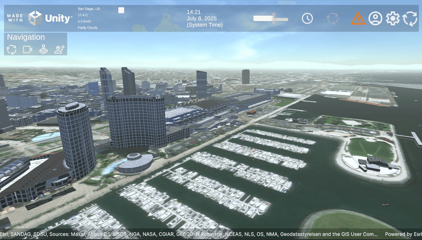
San Diego Convention center and surrounding areas showcasing ArcGIS 3D tiling system within Unity 6.2 (leveraging the Universal Render Pipeline).
Demo highlights
Experience the demo for yourself at the Esri User Conference in San Diego, July 14-18, 2025.
Demonstration of a digital twin of the San Diego Convention Center created with Esri's ArcGIS Maps SDK for Unity.
This demo features real use-cases that demonstrate the full spectrum of Unity and Esri’s capabilities. Highlights include:
- Environmental effects: Realistic simulations of solar panels, wind turbines, and weather impacts.
- Crowd modeling: AI-powered simulation of pedestrian movement, predicting bottlenecks and optimizing flow.
- Train station optimization: A dynamic look at how simulations improve peak transit times.
- Digital twins for asset management: Tools for real-time updates on infrastructure conditions.
The demo is showcased on an Acer SpatialLabs™ View Pro 27, a glasses-free stereoscopic 3D display, providing a true-to-life immersive experience.

Analyzing traffic bottlenecks by integrating AI agents with dynamic line renders, proximity shaders, and collision notification functions.
Applications across industries
The Unity and Esri partnership has far-reaching implications across industries. Here’s a closer look at how specific sectors stand to benefit:
Urban planning
Urban planners can simulate traffic patterns, road designs, and pedestrian behavior to create smarter city layouts. For example, tools can predict the impact of new parks or roads on a neighborhood’s traffic flow before any construction begins.
Infrastructure management
With real-time asset management, infrastructure teams can monitor complex systems like water pipelines, electrical grids, or rail networks. Unity’s spatial simulations pinpoint potential failures, enabling preemptive maintenance that minimizes downtime.
Emergency response
Disaster simulation is another critical application. Organizations can use the technology to visualize natural disasters like floods or earthquakes, allowing teams to craft responsive action plans tailored to geographic vulnerabilities. With geospatial data from ArcGIS, Unity’s simulations deliver accurate disaster models that could save lives.
Energy and environment
From wind turbines to solar arrays, renewable energy companies can assess environmental impacts by simulating weather and other dynamic factors in real-time. Unity’s robust rendering allows for better visualization and greater accuracy which is key to sustainability goals.
Transportation
Airports, train stations, and public transit systems can use this integration to optimize passenger flow, improve logistics, and reduce congestion. Simulations can calculate everything from peak-hour bottlenecks to long-term usage patterns.
Paving the way for a smarter future
The integration of GIS and real-time 3D visualization paves the way for smarter, more efficient communities and workplaces. By combining Unity’s immersive simulations with Esri’s geospatial platform, professionals have the tools they need to address challenges on both local and global scales.
Imagine building cities that function optimally before they are even constructed or scaling up renewable energy grids with fewer risks. For organizations that rely on Esri, the ability to integrate Unity enhances everything from strategy to execution.
Explore Unity tools


